Wednesday, September 24, 2008

Time, Taxation, and the Custom House


The Custom House, just south of Bowling Green, is a microcosm of New York City history. It stands on the site of the Dutch governor's mansion and is directly across from the site of Fort Amsterdam, the stronghold of the Dutch city. It is also a mere stone's throw from Peter Minuit Park, site of Munuit's "purchase" of Manhattan from the nomadic Native American tribe that hunted there. It is in no way an exaggeration to say that the Custom House is at the heart of the embryonic city.


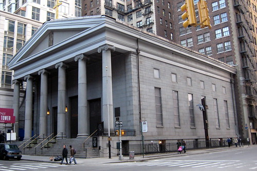
The Alexander Hamilton Custom House, as it is officially called, was completed in 1902 by Cass Gilbert, the brilliant architect who would design the Woolworth Building (1913). More to the point, the Custom House is palatial, internally and externally. This reflects the emphasis on Federal revenue from maritime commerce. It was there, rather than internally through income taxation, that the United States dervived its operating capital.


As early as the 1950s, New York docks were beginning to disappear, first from the East, then from the Hudson River. It is curious that the Civil War propelled New York City to the nation's major port while the years following the Second World War marked its decline. Whatever sea traffic enters the Port of New York in the early twenty-first century enters through Elizabeth, New Jersey and the West Side docks, if they exist at all, are home to amusement malls, like the South Street Seaport or Chelsea Piers, or museums such as the Intrepid Air, Sea, and Space exhibition.


The Custom House has been home to the Museum of the American Indian since 1998. From the location of Minuit's purchase, to the Dutch governor's mansion, to the revenue-producing agent of the early twentieth century, back to a celebration of the Native American inhabitants of Manhattan and America, the site is a living example of the gyres of time.


Monday, September 15, 2008

Romance and the Brooklyn Bridge


Another of the many paradoxes that inform New York City history is the romance that is synonymous with the Brooklyn Bridge. Certainly, its grace is undeniable and neither the Manhattan nor the Williamsburg Bridges can equal it. On the other hand, though, the practical justification for a bridge cheek by jowl next to the Fulton Ferry was to increase passenger traffic between the two cities and hasten Brooklyn’s amalgamation in 1898 into what New York’s late-1960s mayor John Lindsay would call the ungovernable monolith of Greater New York (primarily because he could not govern it).

From the perspective of a New Yorker writing in the early years of the twenty-first century, the random pattern of events seems perfect and planned. The 1850s brought massive Irish immigration to New York. Many of those who came through the Castle Garden immigration station down at the Battery necessarily lived in the city of Brooklyn. Many of those living on teeming Mulberry Street worked in the city of Brooklyn. Officials of both cities recognized the obvious need for easier communication between Brooklyn and Manhattan; hence, the commission they granted the German immigrant John Augustus Roebling in 1861 to conduct preliminary surveys on the feasibility of a suspension bridge over the East River at or near Fulton Street.

Roebling thus starts his work even as Frederick Law Olmstead and Calvert Vaux begin to design Central Park and eliminate by force of law the shanty-town that unemployed Irish immigrants had established for themselves at Lookout Rock, just inside the 59th Street entrance to the park. The Civil War gave some unwanted employment to many Irish immigrants, as Union soldiers, since most could not afford the $300 they needed to purchase a surrogate. Forced military service via a draft lottery spawned the draft riots in 1863.

After 1870, immigration resumes with a vengeance. Italians join the Irish as a second massive wave. They, too, reside in the overcrowded Lower East Side community which comes to be called Little Italy, and they also walk the Brooklyn Bridge to work in the Brooklyn shipyards or on its waterfront. Is it any wonder, then, that St. John’s College takes on the name resigned by a Bronx Jesuit institution that started calling itself Fordham? Is it so surprising that when Emily Roebling, widow of John Augustus’s son George Washington Roebling, finishes the construction of the Brooklyn Bridge in 1883, the little Roman Catholic Brooklyn college on Lewis Avenue has three hundred young Irish and Italian men on its register?

These young Brooklynites would raise their families in Brooklyn; they would become professionals and implicitly challenge the status quo ante bellum. They might, on special occasions, even have $0.75 or $1.50 to attend (admittedly in the upper reaches of the house), a performance of the Metropolitan Opera Company, whose great yellow-brick building, designed by Joseph Cleveland Cady, had risen at Broadway and 39th Street in the very year P.T. Barnum marched his elephant herd across the just opened Brooklyn Bridge to prove its strength. A century and a quarter later, it appears that Barnum was right, about the bridge and about New York.

Tuesday, August 12, 2008

St. Paul's, Trinity, and Old St. Peter's


The expected contrast one might legitimately make is between Trinity, the always comparatively opulent church at Broadway and Wall Street and St. Paul's Chapel at Broadway and Fulton. The churches are at either end of a royal charter dating from the end of the eighteenth century. They originally enclosed the King's College campus, the institution that presently bears the name Columbia University but retains the crown as its crest.


St. Paul's was intended as Trinity's "chapel of ease," a country church corresponding to St. Martin-in-the-Fields, London. Indeed, it is of the same era: 1722-1726 being the dates of construction for St. Martin's, 1766 with the steeple added in 1796 for St. Paul's. St. Paul's was the church George Washington attended immediately following the conclusion of the Revolution in 1783 and after he became President in 1789. Like St. Martin's, London, which it resembles, it was a country church at the very fringe of the city, its front on Chapel, now Church Street, its back turned to Broadway.


Less obvious, but in certain ways more intriguing, is the relationship of St. Paul's and its Anglican tradition to St. Peter's, the first Roman Catholic congregation in New York. The first building on St. Peter's site at Barclay and Church Streets appeared in 1785. The date is important. The Treaty of Paris ending the Revolutionary War had just ended. Trinity Church was itself in the process of constructing its second building at Wall Street, the first having been destroyed in the great fire of 1776. The Trinity congregation was also intent on overcoming the Tory associations it had had during the British occupation of the city. It therefore gave a lease on the square of land at the fringe of its original land grant to the first Roman Catholic congregation in New York.


As a public relations move, it was brilliant. It quelled resistance to the reconstruction of Trinity and quickly established the Episcopal identity of the Trinity congregation as one distinct from the Anglican. Even so, it was only with the second St. Peter's building, constructed in 1836, that Roman Catholic St. Peter's moved architectually away from the appearance of a British chapel of ease. The present building is pure Greek Revival, a perfect Ionic temple, though its interior still recalls an eightenth-century English country church.


Thursday, July 24, 2008

The African Burial Ground


It is difficult to imagine away the tall buildings and traffic noise that dominate Duane Street and the fragment of the African Burial Ground that is memorialized by raised grass plots and a marble monument. The "Negro Burial Ground," as early nineteenth-century maps designate it, actually extends from Reade Street north beyond Duane and east as far as Foley Square.

In a sense, its existence was one of New York's most closely kept secrets. New York historians and city planners always knew it was there, though prospective real estate developers, even after they had learned it existed, preferred to forget it. In 1992, excavations for the Federal office building that straddles the site revealed the burials, hundreds of them, and their numbers made it difficult for the authorities to forget. Surprise of surprises, New York survived without another Federal office building and, though it took almost sixteen years, gained a monument as moving and distinctive the Vietnam War Memorial in Washington, D.C., whose design it echoes.
Here is a little known fact about the location. One approaching the African Burial Ground from the corner of Chambers and Elk Streets at the Surrogates Court building and walking downhill across Reade is walking along the execution track used to send slaves convicted of a capital crime to their deaths. The place of execution was on the island of Little Collect Pond, just at the western edge of Foley Square and half a block from the African Burial Ground Monument. Until Collect Pond was drained in 1829, the swampy surroundings held tanneries, a brewery, a ghetto of freed and escaped slaves, and a poor ground for their burial.

The remarkable thing is the dignified pride with which they were buried: all facing east to the rising sun and to Africa; all with bits of jewelery, stones, or beads that marked their particular region of that continent. When one most despairs of humanity, it is worth remembering the extent to which we live in hope, even after death.

Wednesday, July 9, 2008

The Rhinelander Sugar House


Hidden away behind the Municipal Building is an inconspicuous monument to an atrocity, the Rhinelander Sugar House massacre. During the Revolutionary War, while the city was under the occupation of English troops, the Sons of Liberty conducted a campaign to intimidate Tory residents and harass the occupying army. Some of this was almost playful, such as the erection of "Liberty Poles," stolen pinewood masts furtively set up in public places. Once such place was in northeastern City Hall Park, then simply called the Common, where the statue of Nathan Hale presently stands. This would have been less than five hundred feet from where the Redcoats were bivouacked.

Often, though, the actions of the Sons of Liberty more closely resembled what we might nowadays call terrorism. Homes and businesses belonging to British sympathizers were destroyed by fire in the middle of the night, and in 1776 an enormous fire spread north from Pearl as far as Vesey Street.

New York was, however, a city that generally supported England and its Royalist citizens demanded that the occupying army take strong measures against the Sons of Liberty. Makeshift prisons appeared in various places of the city, among them the Rhinelander Sugar House, a warehouse for the storage of Caribbean sugar that stood at Duane and Rose Streets until 1892. The prisoners in the sugar house were allowed to starve. Indeed, during the English occupation of New York City from 1776 to 1783, it is estimated that 11,000 revolutionists died in such prisons.

When the sugar house was demolished, a loft called the Rhinelander Building replaced it. Several of the sugar house prison windows were incorporated into the loft building, which itself was demolished in 1968 at the construction of One Police Plaza, the central New York City police headquarters . One section of the sugar house wall was transported to Van Cortlandt Park in the Bronx and re-erected near the Van Cortlandt mansion. A single window and its surrounding brickwork was incorporated into a small monument just behind the subway arcade of the Municipal Building.

Friday, June 27, 2008

Thomas Dongan's Swamp


Thomas Dongan, the Irish Catholic and Royalist also known as the Second Earl of Limerick, was provincial governor of New York from 1684-1688. He is remarkable for two things; he permitted Catholics to enter the royal colony when he called New York's first legislative assembly, which issued the colony's Charter of Liberties, and he cut a road through the Common on its east side, in effect creating the street presently known as Park Row. He thus anticipated, and hastened the city's development to the north and east.

The Common was considerably wider than it is today. It splayed out beyond Broadway on the west and petered out on the east into a swamp that connected with the Collect Pond, which began at Foley Square and stretched northeast. Today, Dongan's farmer's road feeds traffic into Centre Street one-way north past the Municipal Building.

One would like to think Dongan's religious toleration grew out of egalitarian Englightenment principles. One would like to think his addition of a northeast road grew from his wise foresight of the city's development. The reality is somewhat more prosaic, as it all too often is. By tolerating Catholics, Dongan brought the first wave of cheap immigrant labor into New York. In truth, he had little in common with the Irish Catholics whose toleration he championed except that he was born in Ireland. Dongan was a thoroughgoing Irish aristocrat and a Royalist during the English Civil War. His best friend was James, the Duke of York, and (coincidentally?) the road the Irish laborers Dongan brought into the city constructed also facilitated access to Dongan's own farm.

Dongan also held two Long Island townships by royal patent, East Hampton and Southampton. The patents that established the municipal governing procedures that these towns employ today grew directly from the so-called Dongan Patents.

Thursday, June 12, 2008

Jacob Wrey Mould Fountain


Quantum physicists are either aghast or agog nowadays about the possibility of a T.O.E., a "Theory of Everything." Essentially, the argument runs that singularity is virtually impossible, that all things connect to all other things and one needs, to paraphrase E.M. Forster, "only [to] connect." The disclaimer that must, therefore, precede the body of this essay is that its writer likes the connection idea. One can easily make the argument that synthesis represents the most genuine form of learning. Juxtapose items one and two and discover a third that is neither.

With this in mind, let us think about the City Hall Park fountain. It is less familiarly known as the Mould Fountain after the architect who collaborated in the design of Central Park with Frederick Olmsted and Calvert Vaux. Mould's fountain stood where it presently does, in lower City Hall Park, from 1871 to 1920 astride the Mullett Post Office. In 1920, it was carted up to Crotona Park in the Bronx until Mayor Guliani returned it to where it had started its life. The Mould Fountain has thus traced a neat little gyre that frames its life.

Find the greensward at the southern entrance to the park and there is the Mould Fountain. If one were to have looked there two hundred years ago, there would have been a public "hydrant," the first tap of the new water supply generated by the Croton aqueduct system. Look there today and one finds the fountain, back since the Guiliani years, but surrounded by 1990s gaslights and benches, greenery, but no post office.

The Croton system solved the cholera problem invariably created by Collect Pond. The Croton system allows New York City to justly claim that it has one of the purest water supplies of any municipality in the United States. Water became a starting point for the "conspiracy" discussed in the preceding post, and the problem of low water pressure increased the danger of devastating fires such as those of 1741, 1776, and 1835. Water, "tea-water," fires, conspiracies, a post office in the Second Empire style, and a first public tap. All these things merge in today's lower City Hall Park and its cooling fountain with pathway marking, almost invisibly, what once was known as "Mail Street."


Friday, May 30, 2008

Tea-water, the 1741 Slave Insurrection, and Collect Pond


"Tea-water" is the name that eighteenth-century New York gave to potable water. It was, in other words, safe to use for making tea. In the days before the draining of Collect Pond (the area that includes Foley Square and past the Federal Courthouse to the north), such water was sold at a premium to those who could afford it. Often, it was sold in taverns built above spring water ponds, and one such tavern stood on the northeast corner of Greenwich Street and Murray in 1741. Greenwich Street was the western shoreline of Manhattan and led north to the village that bore the same name as the London suburb. Everything further west, including St. John's Manhattan campus, was created with landfill as more buildings rose and the North River, now better known as the Hudson, filled with tall ships.This was the very rural Out-ward of the city located to the west of the Common (now City Hall Park). The Common was much larger than the present City Hall Park, however, and was intersected by Broadway on the west and Chatham Street, now Park Row, on the east. According to Jill Lepore's marvelous book New York Burning, the tavern at Greenwich and Murray (then merely fields) was the possible meeting place of those who conspired to set fires at various places in the city. These included the royal governor's mansion at the Battery, located where the Custom House (which now houses the Museum of the American Indian) stands. The brackish, cholera-ridden Collect Pond required tea-water forays to outlying places like the disreputable tavern located in the field to the west of the Common. It threw together resentful slaves, poor whites, and a few greedy businessmen who sought to create chaos and snap up property along Pearl Street to the Battery. There were undoubtedly fires set throughout the winter and spring of 1741, and there were more than thirty slaves executed and buried in what is today the African Burial Ground on Duane Street. The irony is that there may never have been a slave "insurrection" at all, rather a terror campaign designed by have-nots to frighten the wealthy into selling their properties cheaply.Oddly, this entire event centers around the question of New York's water supply and its safety. The model system known as the Croton that New Yorkers enjoy today is a direct consequence of New York's eighteenth-century cholera epidemics. Its first "hydrant" or public tap stood where the Jacob Wrey Mould Fountain cools visitors to City Hall Park.

Wednesday, May 28, 2008

Newspaper Row


Park Row, paralleling Broadway on the east side of City Hall, has undergone a remarkable series of transformations. From a mere cowpath marking the boundaries of Dutch bouweries, or farms, it briefly became Chatham Street. New York was then a British city, and Chatham Street was a mere extension of the Broadway theatre district.
The Park Theatre, at 25 Park Row off Ann Street, was the focus of New York theatre activity in the years immediately following the Revolutionary War. It survived from 1798 to 1820 when it burned down, then to 1848, when it burned down again! Ironically, it survived the 1835 fire that threatened St. Paul's Chapel and destroyed shops and warehouses from Pearl Street to Broadway. Only the carriage drive of the Park Theatre remains, marked with the enigmatic street sign "Theatre Alley," which continually puzzles even native New Yorkers.
In the years immediately before the Civil War, Park Row became informally known as "Newspaper Row" because all of the city's great dailies had their offices on Park Row opposite City Hall. In fact, the New York Tribune office, Horace Greeley's newspaper located where Pace University now stands, became the starting place of the nativist disturbances that ultimately became the Draft Riots of 1863. Greeley's statue is presently on the City Hall grounds immediately across the street.

Friday, May 23, 2008

The Transportaton Building


Quite literally, every foot of the City Hall area has enormous amounts of history attached to it. The challenge, particularly for young people raised on virtual everything, is to learn to feel that history when standing at a given site. For example, immediately across Vesey Street on the St. Paul's Chapel side of Broadway is the Transportation Building. This is a perfectly ordinary looking structure of early twentieth-century vintage. What it replaced was the Astor Hotel, the most luxurious hotel of the middle and late nineteenth century. It was on the steps of the Astor that Abraham Lincoln, on the way to his first inauguration, gave an impromptu speech to a New York street audience frightened about the impending dissolution of the Union. I think of this especially in these times when effective leadership seems so wanting. I sometimes ask my students to stand on the place where the Astor's steps used to be. Of course, I cannot know what they are feeling as they do this. Possibly, they just think they are humoring another of my eccentricities, but I like to think they feel something that ties their present to the nation's past.

Wednesday, May 21, 2008

City Hall Area


One thing I especially want students to notice is that three centuries of New York City history exist on the Broadway block between Fulton Street and Vesey. If you would like to comment on this observation or on the several suggested on your syllabus, do so. (Photo of St. Paul's Chapel from j.klo on flickr.com)